_compressed.gif)
Read the article
here.Vedang is a high school student from Fremont, CA with a lot of curiosity and not enough hours in the day. He does research in atmospheric science and builds tools for people who need them. He likes working on problems that sit at the intersection of science and software, and is always looking for the next thing to learn.
Weather balloons see things. They cross oceans at the dead of night. Drift through cloud layers over Finland while the ground is dark and asleep. Hold altitude for weeks above the mighty Pacific, sampling air previously untouched by man. They go places, witness things, and their data collection feeds into a powerful AI weather forecasting model.
Previously, the only way to understand the balloon's life was to see a spreadsheet. Lat, lon, altitude, time. No disrespect to database schemas, they are useful. But this mathematical reduction of a beautiful life is tragic.
I wanted to fix that.
What is Mission Viewer?
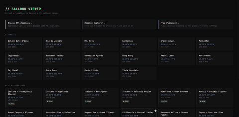
The Mission Viewer is a 3D flight visualization tool. You type in a mission number and it reconstructs the entire journey with the real terrain, real clouds, real sky and with a camera that follows the balloon through its whole journey.
It is not a simulation. Every position is real telemetry. The balloon you see actually floated there.
Why?
Here we find two answers: the practical one and the honest one:
Practical answer: When you work with dense atmospheric data every day, it's easy to forget the data you see in a spreadsheet is a place. A real balloon you launched floated through real air at a real moment in time. Something happened up there with the technology you built. The Mission Viewer makes that visceral, and once it's visible, things you could never articulate before, suddenly click. Why did the descend happen? What did the atmosphere look like at 700 hPa? You stop reading the flight and start living it.
Honest answer: I thought it would be cool. And someone agreed with me.
How it works
_compressed.gif)
The terrain is Google's Photorealistic 3D Tiles: actual satellite imagery draped over real elevation data. When a balloon crosses Finland, you see Finland. Fjords, forests, the texture of actual ground, not a generic green texture with white specks.
The clouds come from our own sounding data. When you load a mission, the viewer finds the nearest atmospheric profile we collected near that place and time, temperature, humidity, altitude, and uses it to figure out where the cloud layers actually were. A volumetric renderer takes it from there. The clouds seen here are a real representation of what was actually in the sky.
The camera took the most work to get right. A balloon moves gently for days at cruise altitude, then drops fast during descent, attach a camera naively and the footage is unwatchable. So the camera adapts. It slows down during launch to catch the drama of ascent. Speeds up across the long open-ocean cruise. Pulls close to the balloon at low altitude, then eases back at height until the curvature of the Earth fills the frame.
What's Next
_compressed.gif)
For now it's largely an internal tool, a way to inspect, understand, and share our flights. Next up: precipitation rendering, views of our full constellation in motion, and tighter integration with mission control.
But at the end of the day: I just wanted to write the unnamed and faceless balloons a story you could watch.


