Read the article
here.Takeaways
- Atmospheric data is a critical missing input for building more accurate weather models, including conventional physics-based models and AI-based models.
- A NOAA/EMC study of 2022 tropical cyclones found that a relatively small amount of insitu WindBorne atmospheric data improved the accuracy of storm ground track predictions by as much as 18%.
- A similar NOAA/EMC study of the 2023 summer season found that WindBorne data improved tropical cyclone track accuracy by 15% over the Atlantic, a significant statistical improvement.
- In the same 2023 study, storm tracks in the Eastern Pacific improved by 10% at nearly all forecast lead times with a small amount of WindBorne atmospheric data.
The atmospheric data gap
The atmosphere – particularly over oceans and remote areas – remains the most prominent gap in global weather data.
Today, 85% of the world’s atmosphere lacks in-situ observations, according to the World Meteorological Organization (WMO). This not only prevents governments and researchers from building an accurate understanding of the current state of the environment and real-time weather – it also prevents forecast providers of all kinds from building the most accurate weather and climate forecasting models.
At WindBorne, we design, manufacture, and operate the most comprehensive atmospheric sensing constellation on the planet. Our balloons, which we launch daily across three continents, can autonomously fly for more than 40 days; our balloons gather up to 150x more data per dollar than conventional weather balloons, which can only fly vertically for a few hours from a single point of launch.
Better data, better forecasts
Studies by third parties such as NOAA have found that WindBorne data significantly improves the accuracy of conventional weather models.
NOAA and the Environmental Modeling Center (EMC) have examined the impact of a small amount of WindBorne data on Global Forecasting System (GFS) predictions. To assess the efficacy of our atmospheric data, NOAA/EMC recently ran GFS retrospectively with and without WindBorne balloon data for the 2022 tropical cyclone season.
The addition of our data from about 170 balloon flights over 3 months reduced the average tropical cyclone track error by as much as 18%. (See NOAA/NCEP’s presentation of these results at the American Meteorological Society (AMS)’s January 2024 conference here.) Our balloon sensing scale today has about doubled since the time of this 2022 observation period.
In a similar study of the 2023 summer storm season, NOAA/EMC found that WindBorne data gathered by 137 balloon flights over 3 months (Aug 1 through Oct 30, 2023) improved tropical cyclone track accuracy by 15% over the Atlantic, a significant statistical improvement.
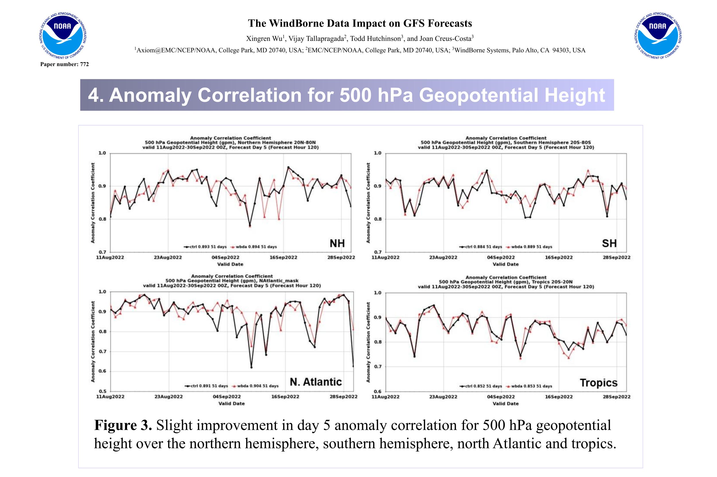
In the same 2023 study, storm tracks in the Eastern Pacific improved by 10% at nearly all forecast lead times with a relatively small amount of WindBorne atmospheric data. Key forecasting metrics such as 500 millibar height and wind speed and direction were also improved in most regions, with the largest benefit over the Arctic.
Growing impact with scale
WindBorne’s ability to improve weather forecast accuracy through more comprehensive atmospheric sensing will continue to grow as we scale our global balloon constellation. We currently launch about 100 balloons per month and are rapidly increasing our production and launch cadence with the ultimate goal of powering a constellation of 10,000 simultaneously aloft balloons.
Through our in-house modeling work via our AI forecast model WeatherMesh, we continue to make additional, even more significant gains in forecast accuracy. Our study of eight major 2022 tropical cyclones found that WeatherMesh could predict storm ground tracks about twice as accurately as leading physics-based forecasts.
A Closer Look
Here are the enlarged versions of the images above
.png)
.png)
.png)
.png)
.png)


