Read the article
here.No single weather model gets everything right.
NWP models like ECMWF IFS and GFS encode decades of physics but run on fixed schedules with coarse update cycles. AI models like WeatherMesh and AIFS can be faster and capture patterns that physics-based models miss, but each has its own biases and blind spots.
MetaMesh is WindBorne's first multi-model blend. Incorporating WeatherMesh, our AI forecast model initialized with our proprietary balloon observations, MetaMesh has access to atmospheric signals that no other blend can replicate.
What is MetaMesh?
MetaMesh is a deterministic blending model that ingests forecasts from multiple AI and NWP sources and weights them dynamically. The specs are as follows:
- Resolution: Point
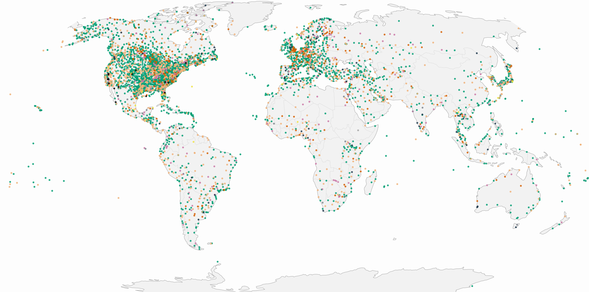
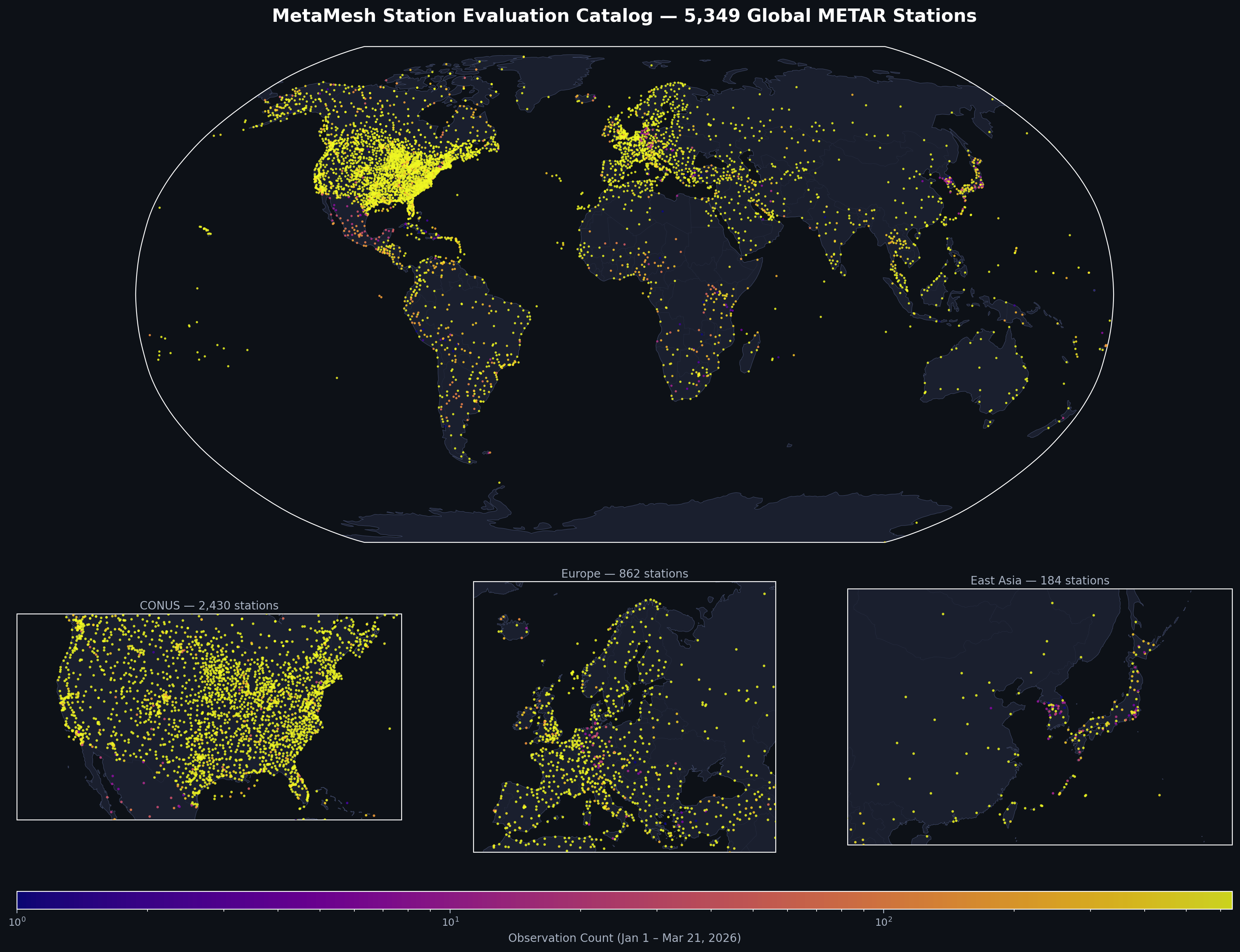
- Coverage: Global (dynamic), with enhanced accuracy at 5,349 METARs stations in the US (static)
- Forecast horizon: 360 hours (15 days)
- Forecast timestep: Hourly
- Update frequency: Rolling: MetaMesh will rerun/update as each input model arrives; full refresh every 6 hours
- Input models: HRRR, GFS, GFS ens, IFS, IFS ens, AIFS, AIFS ens, WeatherMesh Models
- Key surface variables: 2t, 2d, msl, 10u, 10v, 100u, 100v, 10m wspd, 100m wspd
- Backtest availability: Live forecast product only
Because MetaMesh incorporates WeatherMesh as a core input, it inherits two structural advantages that no other blending system has:
- Proprietary observational data. WeatherMesh is the only AI weather model initialized with WindBorne's Global Sounding Balloon network — in-situ observations from altitudes and regions that radiosondes and satellites miss. That data flows through to MetaMesh.
- AI-native data assimilation. WeatherMesh runs on WindBorne's proprietary AI DA system, meaning it doesn't depend on ECMWF or NOAA for its initial conditions. MetaMesh blends a model that sees the atmosphere differently from every other input.
How MetaMesh Works
MetaMesh blends dynamically, constantly adjusting its weights based on proven accuracy. Rather than applying fixed weights (e.g., "60% ECMWF, 40% GFS"), MetaMesh learns optimal weights that vary by
- Lead time: model skill rankings shift as you go from Day 1 to Day 15
- Variable: the best model for 2m temperature isn't necessarily the best for 100m winds
- Region: ECMWF may lead in Europe while WeatherMesh outperforms in data-sparse oceanic regions where our balloons fly
- Seasonality: some models perform better at certain times of the year and by constantly updating weights based on recent verification, MetaMesh can adapt to those changes
These weights are learned at the point level, not a global grid that’s interpolated down. MetaMesh is trained and optimized for individual coordinates so the blend learns which models perform best at that specific location.
This is achieved through two complementary approaches:
- Station-optimized ”static” MetaMesh (trained on METAR stations): currently MetaMesh is trained on al 5,349 METAR stations in the US. Using stations tends to produce more precise surface forecasts but limits us from atmospheric variables, which is why we have the second approach below.
- Globally flexible ”dynamic” MetaMesh (trained on ERA5 analysis): since ERA5 is gridded across the globe, MetaMesh can request a forecast at any point (not just the “static” METAR stations) and incorporate a more comprehensive set of variables such as upper air data. The tradeoff of training on ERA5 is the smoothing effect and slightly less accuracy in forecasts than training on stations.
The tradeoff is precision vs. coverage. Static forecasts typically boast higher forecast accuracy but fewer variables and geographic coverage.
Training and Validation
MetaMesh is trained on 6 months of historical forecast and verification data. Because it’s learning how to weight existing forecasts (not model the atmosphere from scratch), MetaMesh requires a relatively short training window and keeps the blend tuned to recent model performance.
Weights are recalibrated daily so the blend continuously adapts to model upgrades, seasonal skill shifts, and changes in the data observation network, (including our expanding balloon constellation, WindBorne Atlas). The result is a model that's always fully trained but never stale.
Validation uses a 5-fold blocked cross-validation, measuring percent reduction in RMSE vs. the best individual input model. This is a deliberately high and dynamic bar: we’re comparing against whichever single model performed best for each variable and lead time, not against the average.
What’s unique about MetaMesh
Multi-model blending isn't new. But MetaMesh includes signals no other blend has access to. While every other blend on the market combines some subset of the same public models (working from the same observational inputs and the same initial conditions), MetaMesh is the only blend that includes WeatherMesh - a model initialized with proprietary balloon observations and running on independent AI data assimilation.
We built MetaMesh with the single objective of consistently outperforming the best individual model. MetaMesh was trained not just to beat the average, but to come out on top of whichever model that happened to be the best performing model at every variable, lead time and region. If ECMWF is best for European 2m temperature at Day 3, MetaMesh has to outperform this. If WeatherMesh leads for 100m winds over ERCOT at Day 7, that’s a new bar. See below for results.
To be the most accurate model, a model should also be the most up to date. This is why MetaMesh was built to update on a rolling basis. For example, when ECMWF publishes at ~05:30 UTC, MetaMesh incorporates this immediately (you don’t need to wait for another model to publish 30 minutes later). In other words, MetaMesh re-blends on a rolling basis as new models publish throughout the day, and delivers hourly timesteps across the full 15-day horizon.
Results
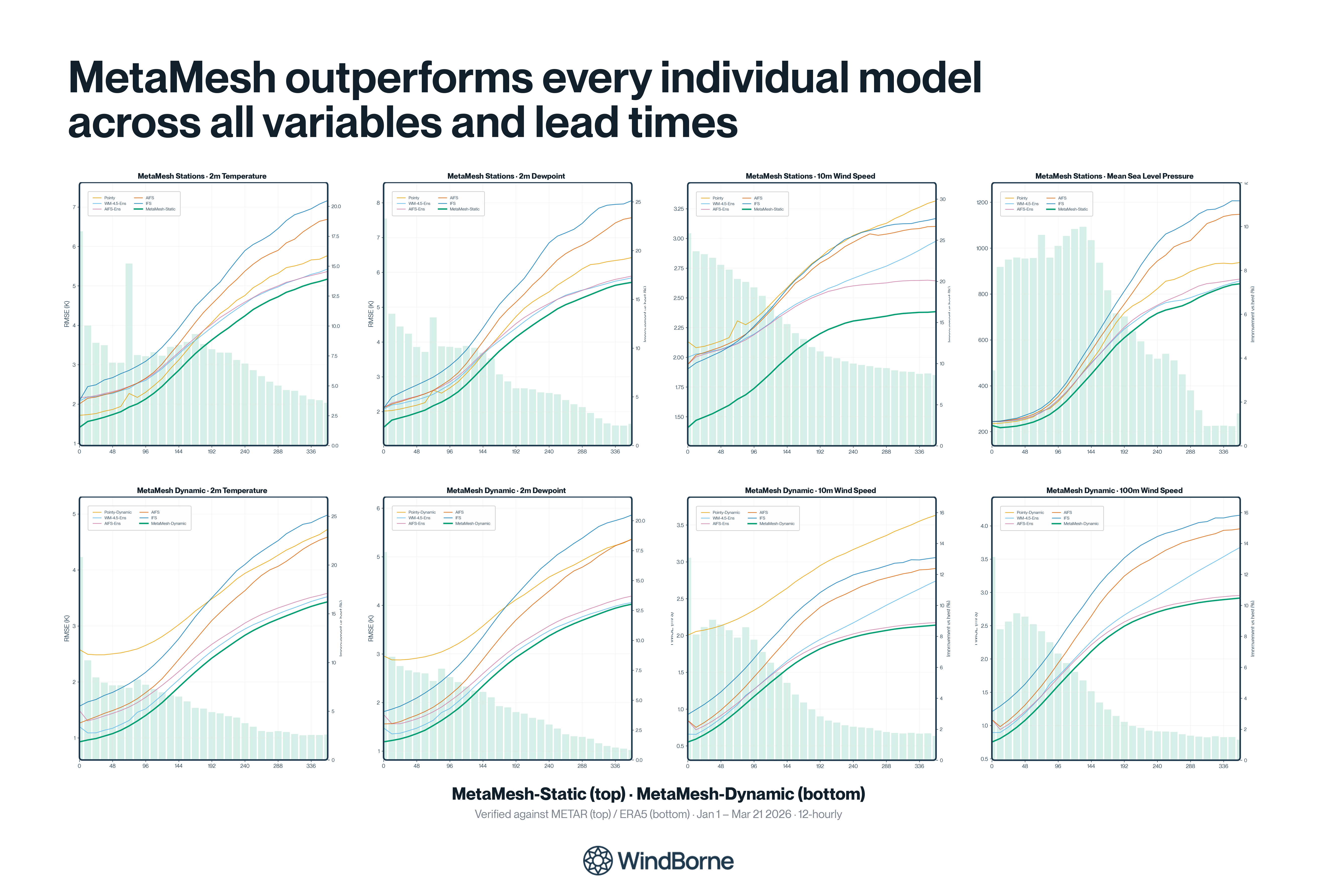
Beating the Best Input Model
The point of blending is to produce a forecast more accurate than any single model on its own. MetaMesh clears that bar across every variable and every lead we track. The margin is largest in the 24-72 hour window where input models disagree most, then compresses toward Day 15 as models converge.
Take 10m wind speed. At short range, MetaMesh beats the best single model by roughly 10% on RMSE. By Day 15 that margin compresses to about 8% as the input models converge. On 2m temperature, MetaMesh holds a 15-20% edge in the 24-72 hour window before narrowing at extended horizons.
WeatherMesh’s Contribution to Accuracy
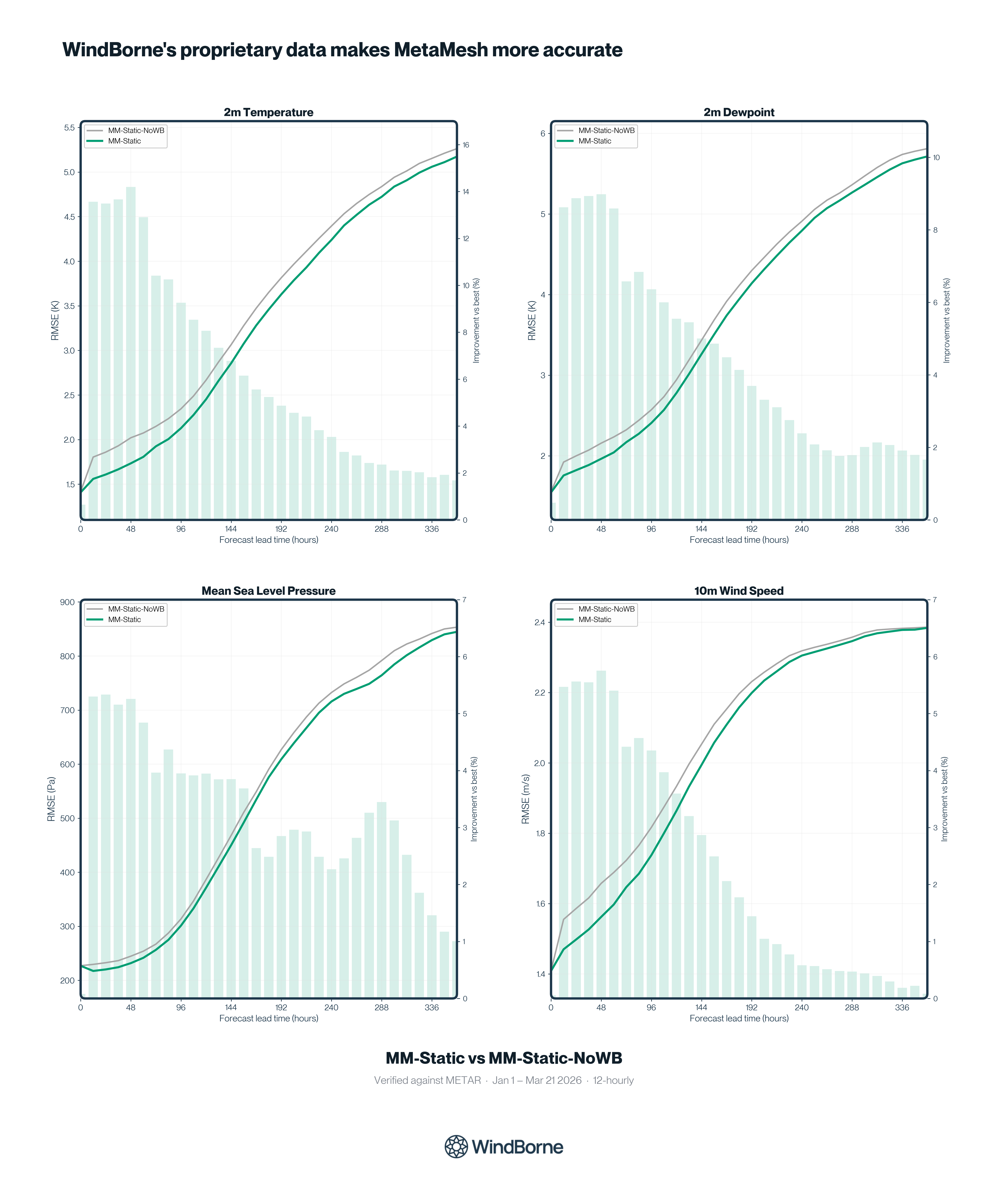
MetaMesh is the only blending system in the market that includes a model initialized with WindBorne's Global Sounding Balloon (GSB) network. To quantify how much that proprietary input actually matters, we ran the same blend with and without WeatherMesh included.
Adding WeatherMesh to the blend reduces 2m temperature RMSE by ~6% on average, with peak gains of ~14% at Day 2. The lift is consistent across variables: dewpoint improves 4%, mean sea level pressure and wind speed each improve by 2-3%. Every gain here reflects what just ~300 balloons contribute today. The constellation is on track to double every 6 months, indicating that the WeatherMesh advantage shown here is the only the starting point.
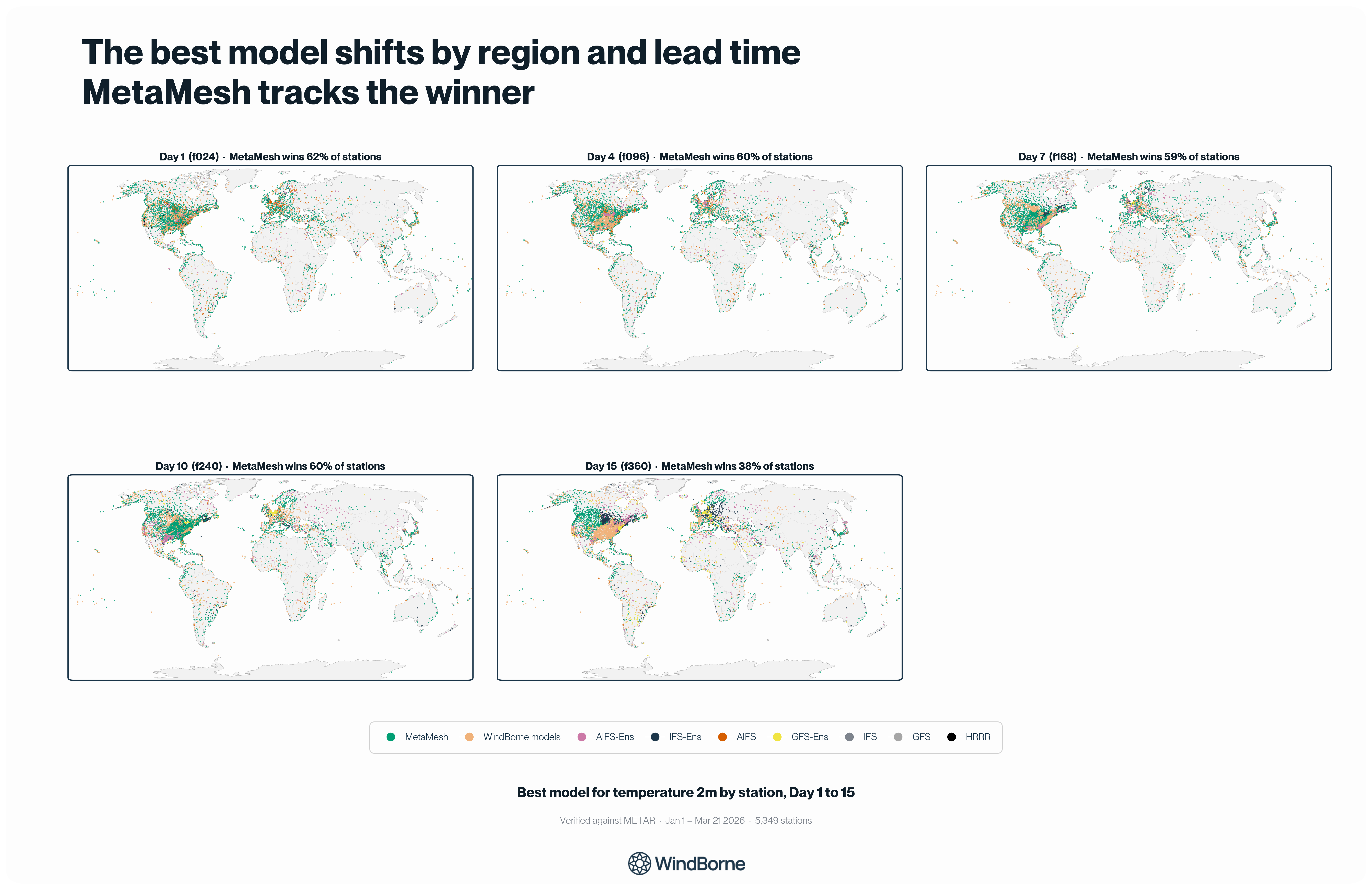
The best model changes by location and lead time; MetaMesh captures this
Model skill shifts by region, by lead time, and by variable. For example, ECMWF tends to lead across Europe while WeatherMesh holds an edge in data-sparse regions where balloons fill gaps other observing systems miss. MetaMesh learns these patterns at the station level rather than picking one model globally, which is why it can track the winning input as it shifts across geography and horizon.
Here’s an example with AIFS-Ens below. On Day 1, it outperforms at ~6% of stations with no regional pattern. By Day 10, its footprint grows to ~9% and by Day 15 it climbs to ~11%, taking clear pockets of the US Southeast. Commit to AIFS early and you lose at short range. Ignore it and you miss its long-range edge. MetaMesh captures both by re-weighting as the skill picture shifts.
Rolling updates cut error as each input model publishes
Most blending systems refresh on a fixed cycle, which means forecasts sit stale for hours while waiting on the slowest input to arrive. MetaMesh re-blends the moment any input model publishes, so the forecast you pull at any time reflects the freshest available data rather than whatever was ready at the last scheduled cycle.

How to Access MetaMesh
MetaMesh is accessible via REST API with JSON and gridded Zarr response formats.
Because MetaMesh dynamically recalibrates its weights as new input models arrive, historical backtests would not accurately represent live model performance. For this reason, MetaMesh is available as a live forecast product only.
API documentation for MetaMesh is now available at api.windbornesystems.com.


