
Read the article
here.Our AI global forecast model, WeatherMesh, which we announced in February, continues to exceed major forecasts such as the National Weather Service’s Global Forecast System (GFS) and the ECMWF’s Integrated Forecasting System (IFS) in predicting key weather metrics. (You can check out our real-time and historical performance on our Benchmarks page, with metrics such as 500mb geopotential, u-wind RMSE, v-wind RMSE, and 2m temperature RMSE).
In addition to publicly sharing real-time benchmarks, we continue to run retrospective case studies to examine how WeatherMesh would have predicted past major weather events compared to other models. To that end, we’re proud to share the results of our 2022 global tropical cyclone season case study, spanning eight major 2022 global tropical storms.
We compared our AI model to GFS for this 2022 storm study, because GFS forecasts were available for all storms including typhoons. The study spanned typhoons Hinnamnor, Muifa, Nanmadol, Noru, and Roke, as well as hurricanes Fiona, Ian, and Orlene.
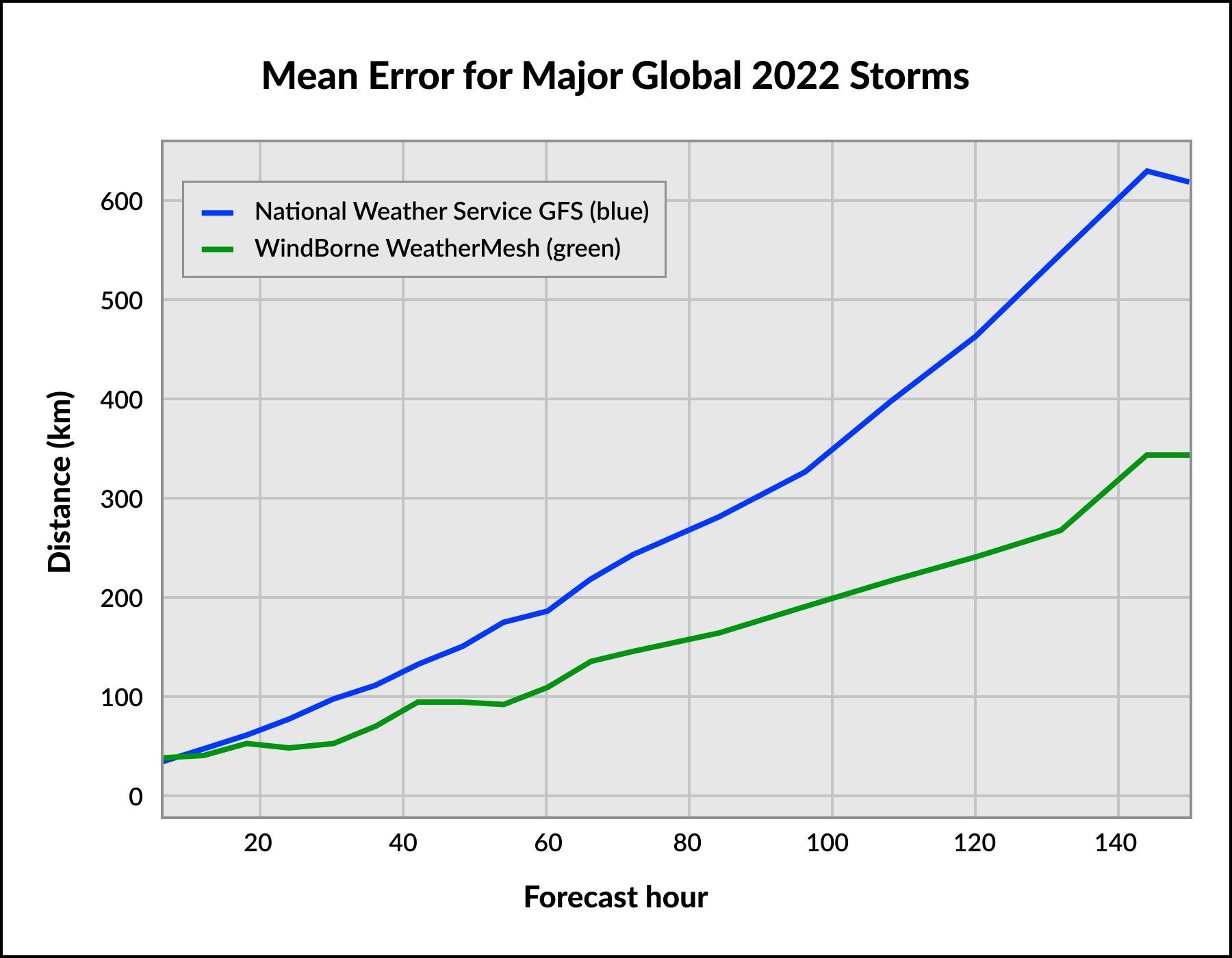
Key Takeaway: WeatherMesh’s average ground track error (the primary way forecast providers define and measure prediction accuracy) is 40% to 50% lower than GFS throughout the eight storms’ duration, meaning WindBorne’s forecast was about twice as accurate as GFS.
We plotted WeatherMesh’s track error based on one forecast each day at 0Z, from storm conception through landfall and/or duration. See header chat above. (It’s worth noting WeatherMesh standardly generates one-hourly forecasts every six hours. This is much more detailed than other top AI-based forecasts such as Google DeepMind's GraphCast, which produces six-hourly forecasts every six hours).
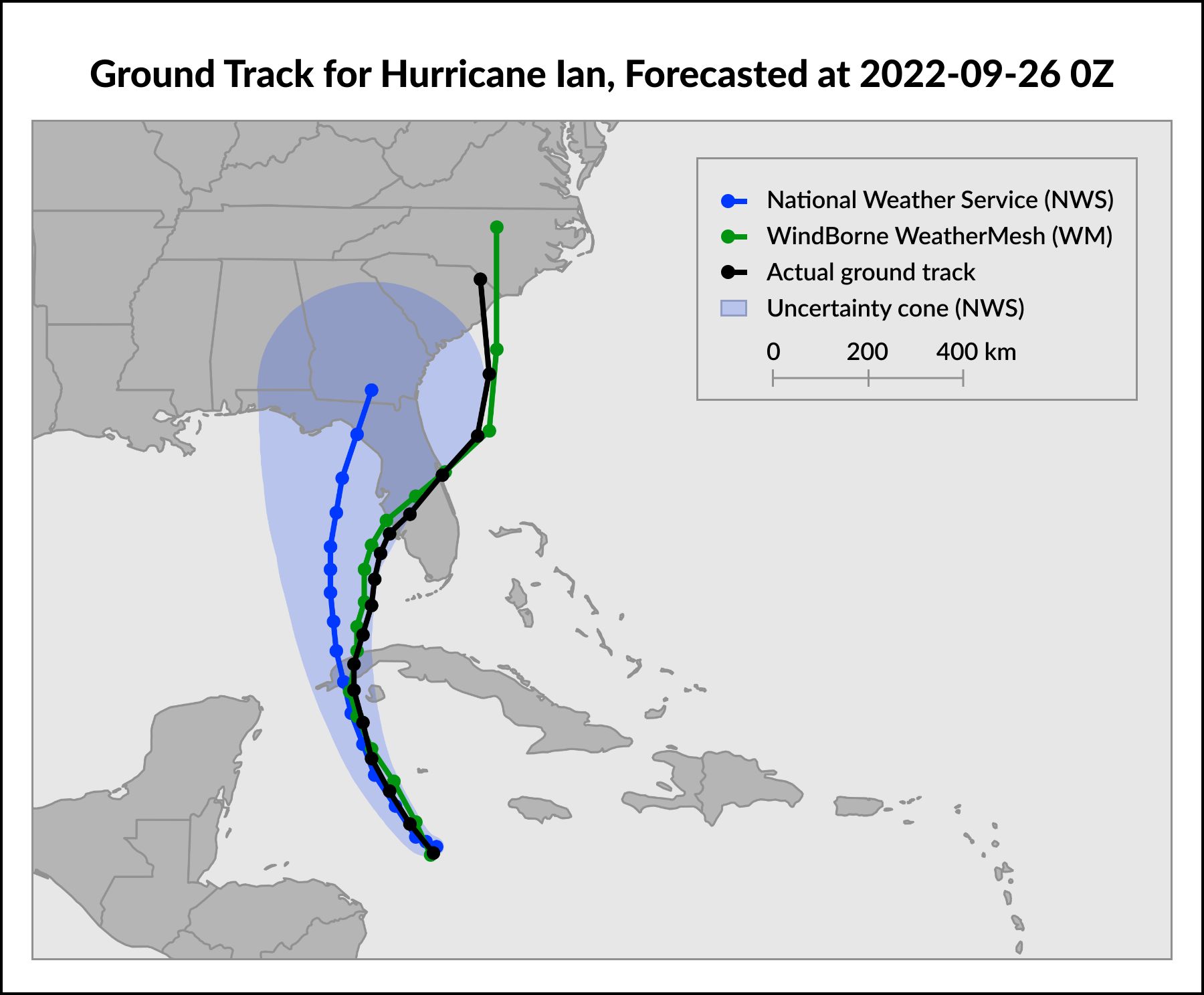
WeatherMesh has predicted hurricane tracks more accurately than the GFS and NWS in every analysis we’ve conducted to date. For example, we recently shared results for WeatherMesh’s retrospective forecast of Hurricane Ian, which predicted Ian’s landfall 200 km more accurately than the NWS at a lead time of about 70 hours. WeatherMesh also continued to predict Ian’s eastward path across Florida between 300 km and 400 km more accurately than the NWS throughout the next 50 hours, a striking improvement.
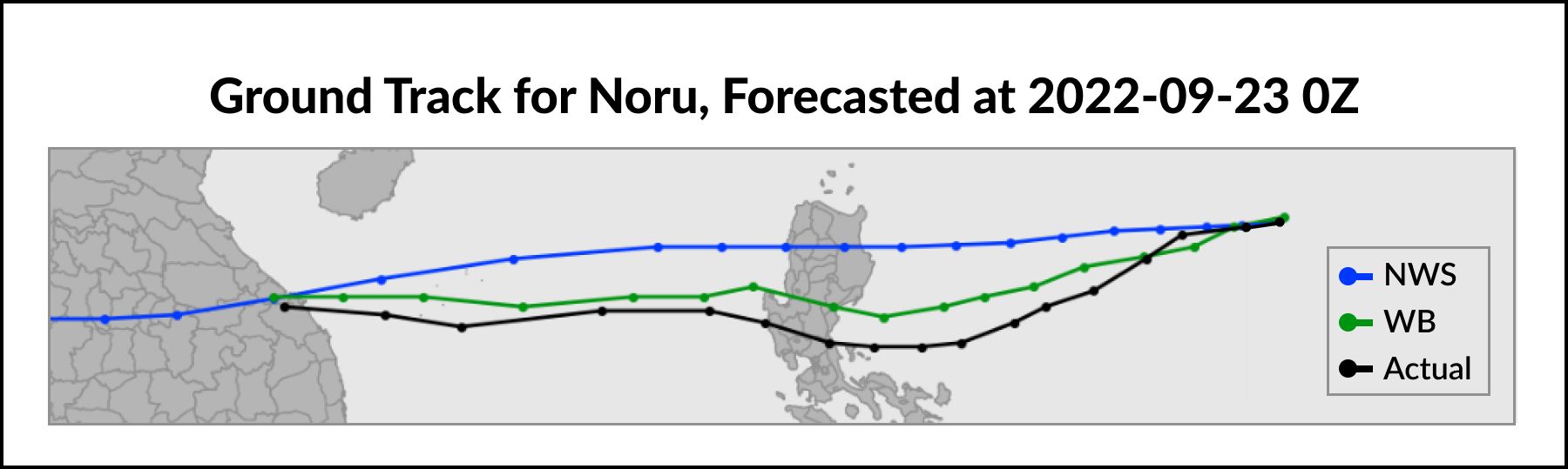
You can see a few examples of individual storm forecasts, which contributed to our 2022 storm season study, below:
.jpeg)
Affected Countries: Japan, South Korea, Taiwan, the Philippines, Russia
Fatalities: 20 people | Damage: $1.81 billion
Affected Countries: ABC Islands, Cayman Islands, Colombia, Cuba, Jamaica, Southeast United States, Trinidad and Tobago, Venezuela
Fatalities: 161 people | Damage: $113 billion
Affected Countries: Cambodia, China, the Lao People’s Democratic Republic, the Philippines Thailand, Vietnam
Fatalities: 40 people | Damage: $110 million
Improving Global Forecasts
Both forecast modeling technology and observation data are key to advancing global forecast accuracy. Weather is a global system in which weather patterns often originate over remote areas such as oceans and then propagate thousands of miles to more populated areas. As a result, in-situ data collection is critical on a global, ongoing basis in order to understand weather from its earliest stages.
Case studies like this demonstrate the ability for groundbreaking forecasts like WeatherMesh to have tangible, real-world impact. They make our team even more motivated to continue to advance our global in-situ data collection and deep learning forecast modeling. More accurate forecasts mean people everywhere can make more informed, safer, and more sustainable decisions every day.
Follow our Blog to see more case studies, as well as updates on our data collection and forecasting progress.
You can get in touch with the team at contact@windbornesystems.com and find our open roles on our Careers page.


